Thursday, November 21, 2019

Blog 7 My Experience Collecting Data with GPS

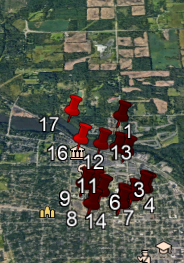
For this lab we were asked to find and map the location of fire hydrants in Google Earth and make a map by uploading a CVS file to Arcgis Online. I used my phone's GPS application. It was very easy to read my cordinates with my phone's application. Creating a KML file and displaying it in Google Earth was also a simple process. 


Google Earth placed most of my hydrants in the middle of the streets. By using Google Earth ruler I estimate that most of my cordinates were off by 5 to 10 meters.

Uploading a CVS file to Arcgis Online was also a fast and simple process. My Map Arcgis Online


If you zoom in on my map you can see that Arcgis Online placed my hydrants closer to their actual positions.  I found this lab to be very user friendly and can imagine many ways to use this in many fields.
Thursday, November 7, 2019

My Experience Combining Attribute and Spatial Queries

   Like several of my classmates, this lab was a bit difficult for me. Arcgis has the ability to do so many things and is very useful for anyone needing to make a map. I found that as long as I had step by step instructions I was able to understand and complete the task and apply it to other tasks as long as the process was the same. I had to keep going back to other lessons to complete many of the tasks and rework some things. Part of my problem was I had quite a busy week and had to do the lab over several days and my laptop is having issues. I believe with repetition I will soon zoom through the tasks. I hope to make time to follow some of the tutorials on Ersi.  I found alot of YouTube clips dealing with Arcgis. I think watching and creating maps along with some of the YouTube tutorials and lessons would also be of benefit to me.