For this lab we were asked to find and map the location of fire hydrants in Google Earth and make a map by uploading a CVS file to Arcgis Online. I used my phone's GPS application. It was very easy to read my cordinates with my phone's application. Creating a KML file and displaying it in Google Earth was also a simple process.
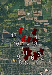
Google Earth placed most of my hydrants in the middle of the streets. By using Google Earth ruler I estimate that most of my cordinates were off by 5 to 10 meters.
Uploading a CVS file to Arcgis Online was also a fast and simple process.
My Map Arcgis Online
If you zoom in on my map you can see that Arcgis Online placed my hydrants closer to their actual positions. I found this lab to be very user friendly and can imagine many ways to use this in many fields.


No comments:
Post a Comment